
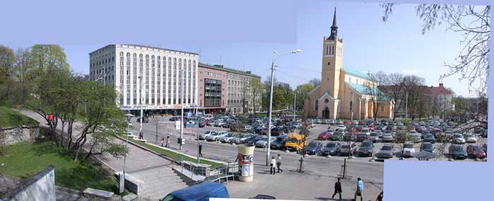
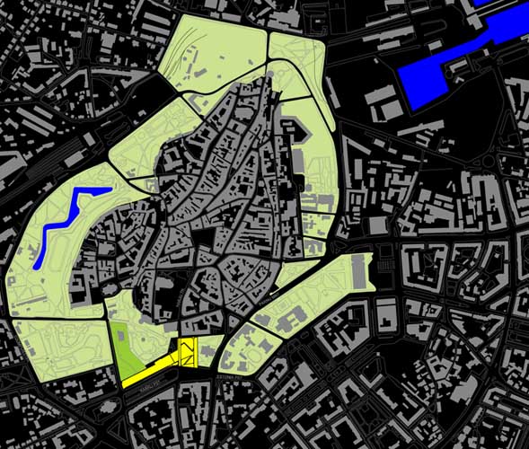

Previous state
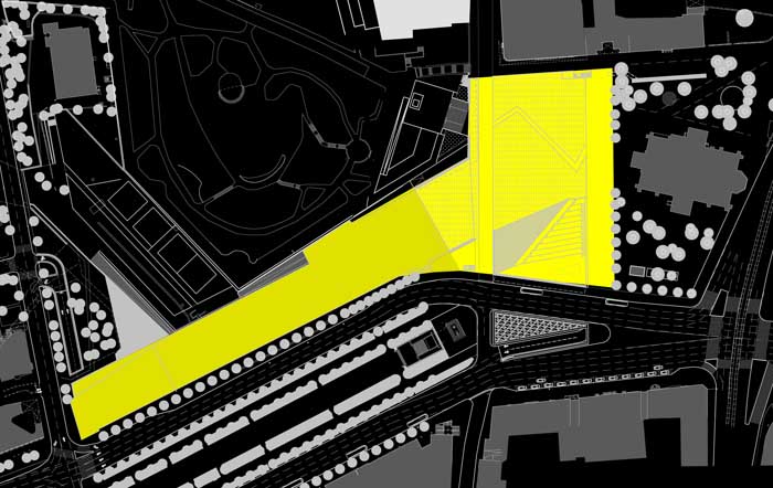
In the Middle Ages, the old centre of Tallin, mostly populated by Baltic Germans, was part of a growing city that was a member of the Hanseatic League. The green belt running around it today replaces the medieval walls and separates it from the Estonian city which, in the mid-nineteenth century, spread out on its southern flank. Between the two different built-up areas, the continuity of the green belt is interrupted by an esplanade that was opened up to become the site of the hay and timber market. This space, which was called Lenin Square when the city was annexed into the Soviet Union, was renamed Liberty Square when Estonia became independent in 1991.Whatever the names suggest, the esplanade was a long way from bringing together the morphological and functional attributes of a square. The greater part of its rectangular perimeter – a hundred metres long and seventy wide – is not defined by aligned facades but by roads, green zones and the occasional isolated building. On the southern edge is Kaarli Avenue, a wide road with a considerable volume of traffic. To the west is Harju Street leading leads directly into the Town Hall Square (Raekoja plats), which is located just three hundred metres to the north while, to the east, is St. John’s Church (Jaani Kogudus) and the gardens that surround it. Only the northern edge is defined by a uniform front of high, well-aligned buildings. Besides its formal inconsistency, the so-called square was basically used as an open-air car park.
Aim of the intervention
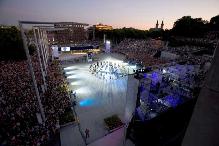
In 1998 the Council called for entries in a competition with the aim of giving relevance to the space and making the most of its strategic centrality. Besides turning it into the main venue for the annual festival held in the Estonian capital, the idea was to get rid of the cars for once and for all so that the esplanade could fulfil the role of a vestibular space that would offer access to the whole pedestrian zone that spreads through the old city centre.Description
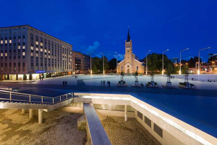
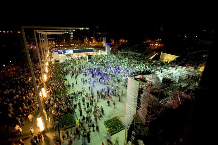
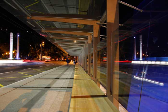
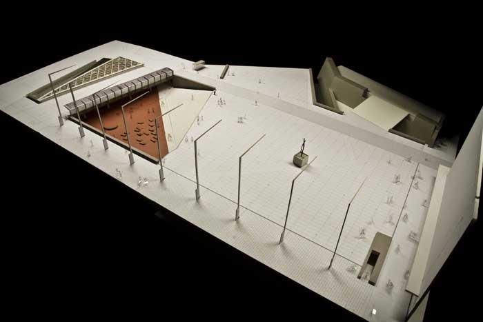
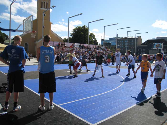
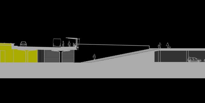
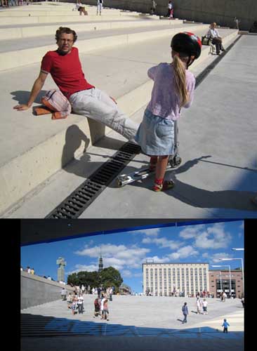
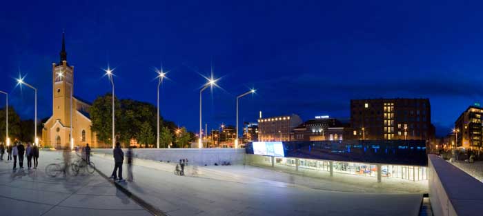
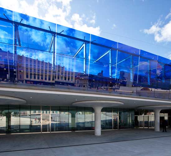
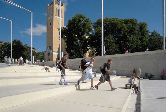
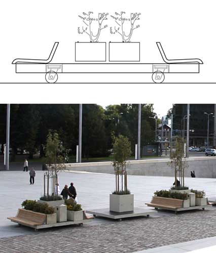
The construction of an underground car park with a capacity of two hundred vehicles beneath the old esplanade has made it possible to free the space of cars and completely refurbish it. The surface, which has been paved with large granite slabs of 120 x 300 cm, constitutes a horizontal space spreading out from the base of the buildings aligned along the north face. The street furniture that equips it, consisting basically of wooden benches and prefabricated concrete plant stands, is set on wheeled platforms that make it possible to shape the space in many different ways and for many different functions according to the needs of the moment. Free of any fixed objects, the platform module has great versatility which means it can be used, for example, to create a dismountable stage for multitudinous open-air concerts. The fact that the space is clear also makes it possible to spread out textile sports surfaces with the appropriate markings for public competitive events. The eastern side of the square is now marked out by nine high streetlights that trace a virtual, rhythmic and unitary front without blocking out the adjoining Jaani Kogudus. In contrast, the western side of the square opens out on to the green belt, where several nineteenth-century buildings have been restored to their previous state to give dignity and visibility to the remains of the fortifications. A space has been reserved here as the location of a monument commemorating the Estonian Liberation War.The southern side of the square abandons the horizontal plane to fold down in order to form a hollow of some four metres deep. A rectilinear ramp runs diagonally across this concavity dividing it into two sections with steps. The eastern sector, with wider, deeper steps, constitutes tiered seating while, on the western side, is a stairway providing access to the new science museum AHHAA. This facility has been constructed beneath the surface of Kaarli Avenue, which forms a roofing slab resting on mushroom-shaped concrete pillars. On the far side of the avenue is a triangular traffic island which contains the ramps giving access to the underground car park. This roundabout has a glass cover in order to provide zenithal lighting for the museum. Built over the slab covering the museum there is a bus stop with a transparent shelter running along the entire length of the southern side of the square. Sustained by right-angled metal brackets, the bus stop cover also folds upwards to form a vertical face in the form of a curtain wall with large cobalt blue sheets of glass. This glass wall is the support for a large multimedia screen that faces the tiered seating in the square.
Assessment
Through a series of coherent decisions, this intervention has judiciously resolved the problems of the previously unchecked urban setting so as to bestow on the esplanade a representative status, versatility and, in particular, a new capacity for spatial containment that at last makes it worthy of being called a square. The previously consolidated northern edge has been well integrated and complemented with the virtual plane defined by the series of tall light posts on the eastern edge and the physical limit achieved by creating a hollow on the south side.Besides constituting a vertical face where the square had no built-up limit, this operation of folding down from the horizontal plane manages, by way of this simple gesture, to endow the space with range of interesting benefits. First, it provides the science museum with natural light and a representative entrance that brings it into relation with the public space, even though it is underground. It has also created a zone of tiered seating that makes it possible to use the square as an open-air performance space that is full of possibilities. Finally, it gives support to a blue glass curtain wall that, besides protecting the square from the hustle and bustle of Kaarli Avenue, establishes a suggestive visual dialogue with the square. From the upper position of the bus stop, its transparency permits an overview of the hollow, while from the lower level and thanks to a slight inwards slope it reflects this view like a mirror.
David Bravo Bordas, architect
[Last update: 02/05/2018]