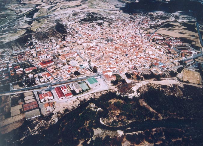
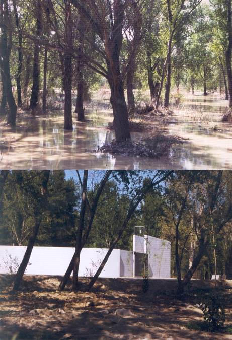
Previous state
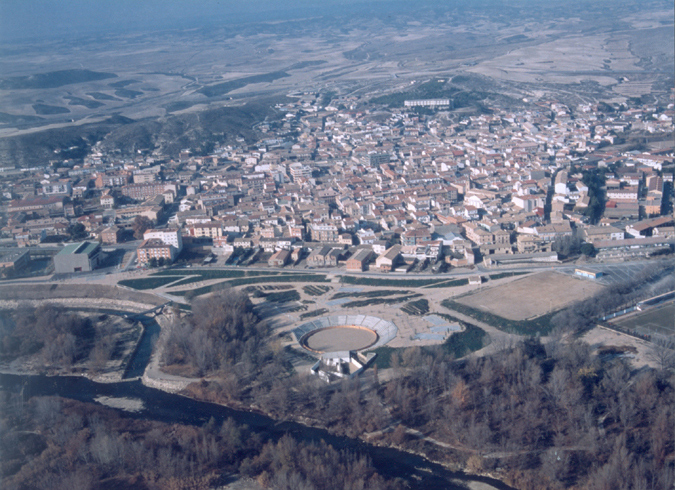
The River Gállego runs in a north-south direction parallel to the urban centre of Zuera. The river course, which is totally natural, changes direction sharply at some points, causing erosion to the town bank, in particular in an area of rapids where the water runs practically at right angles to the bank that separates it from a recently-constructed area of urban facilities. An indiscriminate and sustained dumping of rubbish had endangered the stability of the bank, which was also affected by the periodic rises in the waters of a river that markedly changes its form over the year, while also creating problems of environmental pollution with extremely negative visual and ecological results. The hydraulic capacity of the Gállego as it passes through Zuera was considerably reduced by an accumulation of gravel at different points, and because of the sharp rises in water levels in recent years, while the river bed was gradually shrinking, with the disappearance of some islands. This only aggravated the problems of erosion and the damage to the town-side bank.
Since the end of the dictatorship, the democratic entities of the town have long wished to recover their riverside spaces. In 1990, a small park was constructed at the northernmost end of the river. Despite the fact that it was at some distance from the town centre, it did represent the beginning of a general and growing awareness of this natural corridor. In 1996, the town council prepared a blueprint for recovering the riverbed and the banks with a double aim: fostering civic awareness and mobilisation about the project, and reaching agreement with the Confederación Hidrográfica del Ebro (River Ebro Hydrographical Confederation), which was responsible for the river basin, in an attempt to put an end to the problems of structural instability faced by the town because of the regular onslaughts of the river.
Aim of the intervention
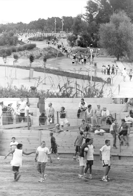
The objective of the project was to remedy the situation of the land between the town centre and the river, which had been used for years as a free-for-all open-air rubbish tip, and to create a new eastern facade for the town, modifying its orientation by opening it up to the river, which had previously been spurned by the most recent constructions on the town's perimeter. The inclusion in the project of a public space that would be a venue for a range of local festivities and functions, among them the annual bull fight, a deep-rooted local tradition but hitherto without a permanent space, meant a growing interest of the town's residents in this project that, in its early phases, involved an intense awareness-raising and educational campaign in the schools of the municipality and its area of influence.
The aims to be achieved in regenerating the river were considered from a number of different angles, standpoints that were integrated into a unitary project where the hydraulic aspects (physical protection of the town centre and functional improvement of the River Gállego), use by the town's residents through developing spaces for different leisure, sporting and cultural activities, the different environmental considerations (improving the quality of the water and restoring the natural course of the river) and town planning (with the aim of including the river as a structural element of the town), were all taken into account by a well-coordinated multidisciplinary team of experts.
Description
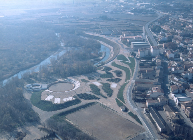
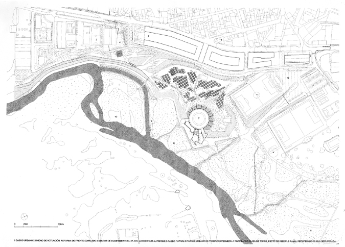
Work on regenerating the riverbed and its banks was carried out on three distinct topographical platforms that, running along the river side of the town, were graded from water level up to the level of the town centre, from the lowest platform that was occupied by a long-standing forest in relatively good condition although completely flooded several times a year when the river overflowed its banks, through an intermediate terrace with scant vegetation and between five to six metres deep in rubble and rubbish, to an uppermost terrace, some eleven metres above water level, where municipal facilities, along with residential buildings, small farms and workshops, had been built facing away from the river.
With a limited budget for achieving these aims, a good part of which would have to be used for aspects that were not clearly visible – cleaning up the land, topographic restructuring to connect the different terraces, constructing a main sewer that would cross the whole area taking the sewage to a new purifying plant, the creation of a new embankment with stabilisation and planting of the banks – the project went ahead, concentrating the work to the maximum and with an austere and rigorous approach to what had to be done.
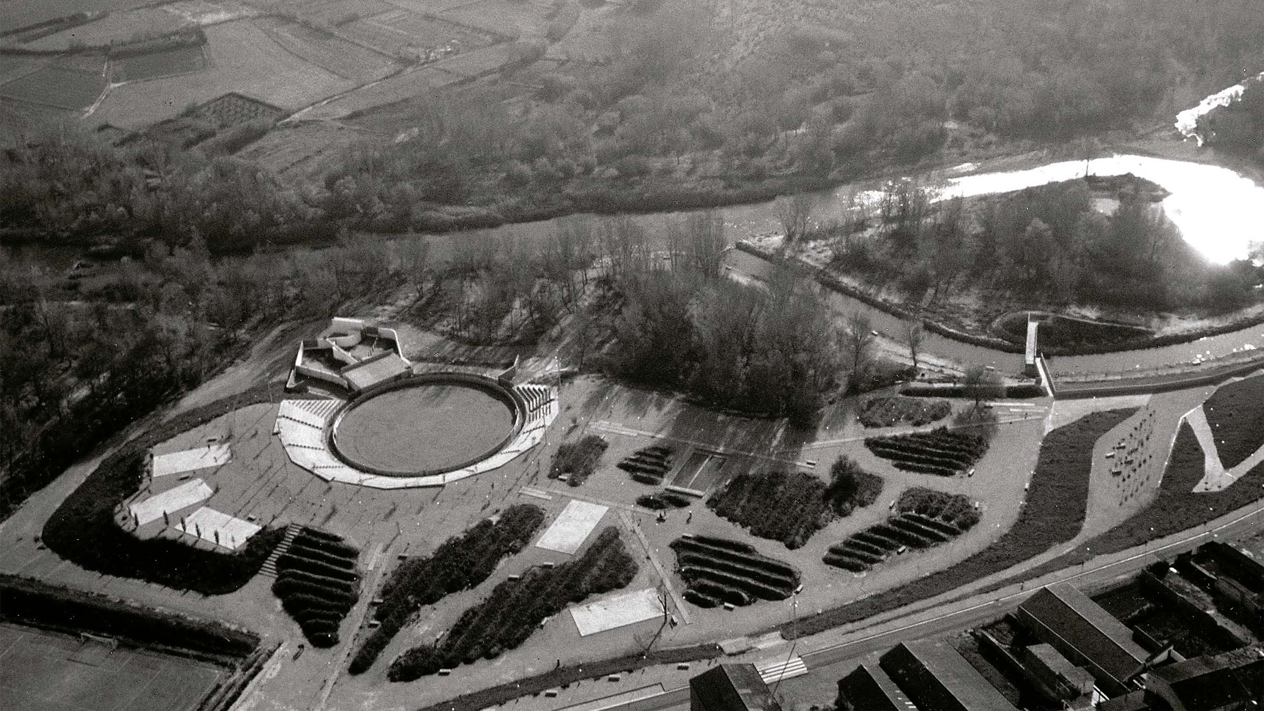
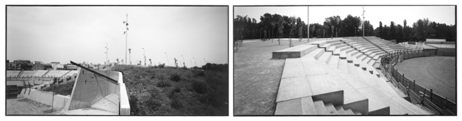
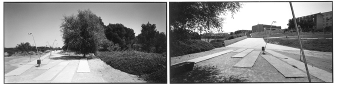
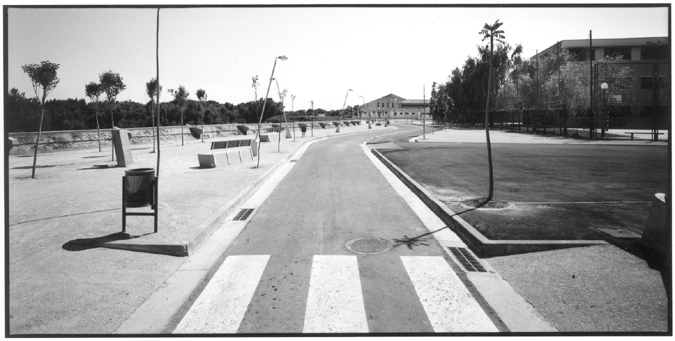
At the level of the top terrace, a winding path was constructed, offering a leisurely stroll through all its twists and turns. This gave easy access to the intermediate terrace where, because of the aridness of the ground, the vegetal soil that had accumulated over the years was reinforced with slight corrections with the distribution of fine layers of concrete to direct circulation through the park. Around these were concentrated the lighting and new paved games areas. The new road along the river, at the same height as the town, has reoriented this face to look out over the river, although this will mean further reforms to the built-up riverside area in future. This new street in the town, opening up new points of access to the river area. organises entry to the park through different public spaces that serve as connection points.
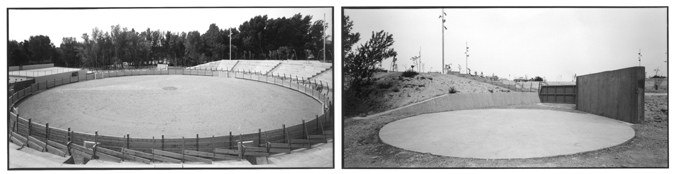
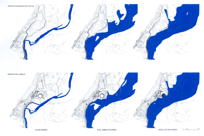
At one end of the now-transformed former rubbish tip, in an area that is concave in shape and enclosed in a slope that relates the intermediate river terrace with the lower bank, an amphitheatre-cum-bullring was constructed to be used for bull-fighting, open-air concerts, and sports functions, sunbathing, social gatherings or for the pleasure of contemplating the river and its vegetation. The graduation of this square, which is supported on the talus of the excavation, increases helicoidally, harmoniously adapting to the natural gradients of the land. The bull pens and the ring are located on the lower terrace. When the river is high, this land is flooded several times a year, up to the embankment that begins the tiers of the grandstand in the square so that, in this natural way, occasional ponds appear in the new river parklands. It was also decided, because of this, that the different elements of the seating, for example transoms, railings and planks would be dismantled when there was no function being held that required them, in order to minimise the obstacles to the flow of water.
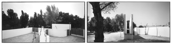
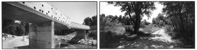
With the construction of a footbridge over an old branch of the river that has been recovered as a navigable canal, it is now possible to reach a small observatory at the highest point of a restructured island where there is a nature classroom that is used for municipal programmes of environmental education. This also enhances the value of the island as a natural reserve. The footbridge, constructed to reflect the irrigation channels in the adjoining fields, is a u-shaped concrete form over transversal walls that offer the minimum possible edge in the direction of the flow of the river, with openings along its length so that it functions like a gargoyle at different points, thereby facilitating the drainage of water from the intermediate terrace into the reconstituted canal below. The lateral faces of the concrete bridge are perforated so as to offer less resistance to the water when the river is in flood.
Work at the lowest level of the river gorge included regeneration of some reaches, the creation of vegetation filters to layer the rising waters, improving natural drainage by restoring pre-existing run-off channels and sealing off points of direct drainage into the river. Old paths were redefined and new ones were created so as to link up the new routes in the flood-susceptible lower platform with the rest of the park's itineraries. In the river area, small bridges were constructed and benches installed under particular trees or at the water’s edge. With the cyclical high waters of winter and spring that flood the lower river basin, irrigating the land for the summer season, the area takes on a completely different appearance, after which the face of the park changes once more as the water slowly disappears.
Assessment
The new river park has meant the creation of a space of physical, natural and social integration in a transitional area between the urban zone and the banks of the River Gállego. These two realities were consolidated as separate entities and, until the intervention, had not had any contact beyond the continual aggression against the environment that had also cut off the area from the town. The work done on the different levels of river terraces, with a degree of intervention that fitted exquisitely with each of the different places concerned, brought about a new reading of the river and the beginning of a dialogue between two realities that had hitherto been cut off from one another. This meant a very significant qualitative step forward in the evolution of Zuera and the town's relation with the river.
The work done on the river bed and the area of the banks has managed not merely to remedy a situation that was threatening the physical integrity of the edge of the town, thanks to the improved hydraulic mechanisms that were employed to optimise the functioning of the river system, but also the regeneration of an abandoned and ill-defined area so that it is now a magnificently equipped public park. This has restored the landscape of the river corridor and reinterpreted the area with a number of measures that have brought about ecological and environmental improvement. This in turn means a new starting point for the sustainable functioning of a natural setting that has been recovered for collective use.
The project is the product of the understanding reached between different branches of the government and it has achieved a clear and effective synthesis of a complex set of aims. This fact is evident in the emphatically beautiful simplicity of the mechanisms employed in the construction of the park and in the architectural features of the restored landscape. By incorporating the different natural levels of the river waters and the areas they define each season, the project permits the rise and fall of the river waters to delineate a park that is accessible every day but one that is constantly changing, creating a setting that illustrates the natural processes of an area that is characterised by the eternal flow of the water.
Mònica Oliveres i Guixer, architect
[Last update: 07/06/2023]